|
Please visit our dedicated GPS site for the latest products and prices
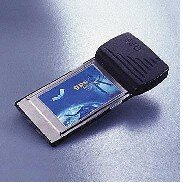
DESCRIPTION
A NEW 12 channel GPS system combining PC Card technology with the $13 billion GlobalPositioning System (GPS) satellites to produce a GPS Receiver on a PCMCIA Type II card.This breakthrough enables users of the ever-increasing array of portable computers,organisers and personal digital assistants (PDAs) to obtain exact location information.The SatNav Card interprets signals received from the GPS network of satellites that circlethe earth to provide data on position, direction, altitude and speed.
The receiver interfaces directly with a host computer via the PCMCIA interface. Datatransfers across the interface to the application software by emulating a serialcommunication port on the SatNav GPS Receiver.
FUNCTIONALITY
The SatNav GPS Receiver is compatible with PCMCIA Release 2.1 host socket services. Itis designed to integrate easily with a wide range of navigation, location and mappingsoftware applications. Its complete location-finding function makes it suitable both forintegration and use in a variety of OEM products.
FEATURES
Compact, low cost, low power. Provides land, marine and airborne users with continuous,accurate position information through the Navigation Satellite Timing and Ranging(NAVSTAR) GPS System available 24 hours a day, 7 days a week, at no charge. Multiplechannel receiver utilises a unique power management feature, reducing the average powerconsumption to 175mW average The Smart antenna meets the dynamic requirements of highperformance aircraft. Position, direction, altitude and speed are presented in an easilyunderstood message format. SatNav maintains a set of satellite orbital parameters both inEEPROM and SRAM, allowing typical satellite acquisition upon power up within 15 secondswarm.
APPLICATIONS
The SatNav Receiver is designed to be integrated with many end-product solutions,including personal applications, transportation, marine, aviation and industrial markets,although it is not limited to these markets. A sample of relevant applications are:-
Transportation - A GPS receiver can help drivers know exactly where they are and, withthe right application software, where they are going.
Emergency - Special service markets such as border patrols and law enforcement agenciesrequire pinpoint accuracy for added security and safety for individuals in a wide varietyof remote areas. The SatNav GPS receiver, with the appropriate mapping application, willprovide the tools need to respond quickly.
SOFTWARE
The GPS PC Card uses standard 16550 UART COM Port I/O Mapping. Engineers can refer to serial.vxd driver programming in Win95/98 or serial.dll. This also applies to in WinCE as well.Development software is available which provides longitude, latitude, speed, time, altitude and show satellite position,signal strength and NMEA sentences. The card is compatible with all leading chart and mapping software packages which acceptNMEA input. This system interfaces to moving mappackages, eg. Autoroute, Route66, Express GB, Autorout Express Europe, Personal Navigator, etc.
Quotation required