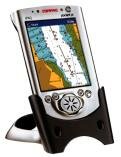
Maptech Pocket Navigator
|
|
| Accurate scans of British Admiralty charts |
| Simply drag the chart using the touch sensitive screen |
| Multiple zoom levels for detailed chart views |
| Course projection and track logging |
| GPS compatible for a complete handheld navigation system. |
|
|
|
|
The NEW Maptech Pocket Navigator is the latest innovation in mapping software. Now you can see full colour, detailed maps and charts on a PocketPC in the palm of your hand.
Using the the software supplied, or your Maptech Navigation software, simply plan your routes and waypoints then save them onto your PocketPC. Take your PocketPC onboard and you have a handheld reference guide. You can even connect a GPS for a complete handheld navigation system!
You can also choose from a range of Road and Street maps so you can also use your Maptech Pocket Navigator on land.