LOCKHEED CITS
The LOCKHEED CITS is a second generation targeting-navigational system.
FEATURES | TECHNICAL INFO
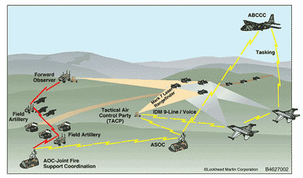
This targeting-navigational system has been developed by conjunction with Lockheed Martin Tactical Aircraft Systems. In addition to all of the normal navigational and mapping functions, the new Close Air Support Integrated Targeting System (CITS) integrates Global Positioning System (GPS) with laser target locators.
FUGAWI/LOCKHEED CITS FEATURES
- Using the laser unit, the TACP observer simply presses a button to determine the range, elevation (angle above horizontal), and azimuth (magnetic bearing) of a target
- Information is automatically passed to the CITS system where it is combined with the observer’s location determined from a GPS receiver to display both the target and observer’s location precisely on a digital map
- Targeting information is then transmitted to the aircraft using a special PCMCIA card that interfaces with military radios
- With an appropriate wireless interface, the CITS program can also display the location of multiple assets such as aircraft or other ground units
- Able to read standard military digital maps and images in their native format.
Images and maps can be rapidly displayed, panned and zoomed in or out with the click of a mouse
FUGAWI/LOCKHEED CITS TECHNICAL INFORMATION:
The following map formats can be directly read by the program:
-
ADRG - ARC Digital Raster Graphics
-
CADRG - Compressed ARC Digital Raster Graphics
-
CIB - Controlled Image Base
- The laser targeting concept is protected by United States Patent Number 4,949,089 held by Lockheed Martin