Mapping Software
MARINE CHARTS, LAND MAPS STREET MAPS MILITARY MAPPING LOCKHEED CITS
FEATURES | TECHNICAL INFO | SYSTEM REQ | GPS RECEIVER REQ
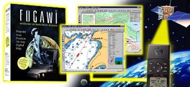
Freedom to go anywhere on the map.
This product is an affordable, feature-packed software
that locates your exact position on land or sea.
This product is a complete navigational system that makes powerful use of the extraordinary GLOBAL POSITIONING SYSTEM. With mapping, you easily create accurate digital maps from any scanned map or existing map database (ie. BSB MARINE CHARTS or USGS TOPOGRAPHIC MAPS). Then, in real-time navigation mode, your exact position is displayed on the map as you move and new maps are automatically loaded as you travel to new areas. North American customers receive detailed street maps of the entire USA as well as the nautical Region 1 Planning Charts on CD. Customers in Europe receive a CD with the complete Road Network of Europe. Customers outside of Europe and North America receive a World Geographic Names CD with over 6.7 million names.
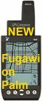
Mapping also brings you all the convenience of computer mapping without having to carry it on your travels. You simply position waypoints and routes on your map with a click of the mouse and then upload them to your GPS receiver for use out in the field. Upon returning to your base, you can download added waypoints, routes and tracks onto the digital maps for analysis.
Mapping is a feature-packed program that is used by major international organizations and the armed forces in critical applications. Please see also Mapping Military or Lockheed CITS.
FEATURES | TECHNICAL INFO | SYSTEM REQ | GPS RECEIVER REQ | TOP
MAPPING ACCEPTS MOST MAPS AND CHARTS:
- Accepts bitmapped maps from a scanner, a map database or a drafting program
- Corrects scanned maps for rotation, skewing, and differential stretching of the axes caused by photocopying or paper shrinkage
- Supports ready-made MARINE CHARTS, LAND MAPS and STREET MAPS
- Automatically imports BSB, Maptech, SoftChart, ChartTiff, USGS DRG and TIF+TFW digital map products
-
Supports many map projections:
- Supports grids from: Australia, Belgium, Canada, Finland, Germany, Iceland, Ireland, Israel, Netherlands, New Zealand, Sweden, Switzerland, UK Ordnance Survey, Military Grid Reference System (MGRS) and UTM.
- Optional extra: support for Swedish government digital maps
Please see our World Maps and Charts section for a comprehensive selection of land maps and marine charts.
MAPPING FEATURES:
 |
|
WHAT MAPPING SHOWS YOU:
- Shows your track and current location on the screen
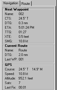
- Full navigational features: speed, waypoints, routes, distance to go, course to steer, magnetic and true courses
- Built-in Odometers and Trip Odometers to calculate distance traveled
- Geographic Name lookup. Look up a name and click to autoload a map.
- Distance and bearing measurement tool
HOW MAPPING WORKS AUTOMATICALLY:
- Plots points and reads co-ordinates from maps with exceptional precision
- Optimizes the number of track points (based on user-specified tolerance) with Smart Track Reduction
- Loads appropriate map from your own digital map library as you travel
- Automatically converts the GPS datum (WGS 84) to the map datum. In fact, users in Sweden, Finland, Austria, The Netherlands, Switzerland and New Zealand will find that the conversion in MAPPING is more accurate than the conversion in their GPS receivers or other mapping programs
- Exports waypoints and tracks with UTM coordinates or latitude/longitude
|
 |
|
HOW YOU WORK WITH MAPPING:
- Select a chart datum from over 100 possibilities or create your own
- Create a waypoint by clicking, eliminating time-consuming plotting.
- Draw tracks and routes freehand. Or draw free-hand around an area on the map and it will accurately calculate the area enclosed
- Select location icons like: boats, planes, cars, hikers or targets that rotate as you change direction. And any icon can mark a waypoint
- Upload waypoints and routes from your PC to your Garmin, Lowrance/Eagle, Micrologic or Magellan GPS receiver for field use or download waypoints, routes and tracks to your PC for analysis or mapping
- Create a Geographical Information System database by clicking on a map location
|
ADVANCED FEATURES
- You can easily move to an adjacent larger or smaller scale map with a click
- Make a trail map by printing your waypoints, routes and/or tracks on your map
- Display the elevation profile for a track or route (Details)
- Make multiple tracks and routes visible
- There is Night and Dusk vision display
- You can attach sound and pictures to waypoints
- MAPPING supports the Kodak digital GPS camera and automatically puts pictures on your maps in the location where the picture was taken
- Synchronize the computer clock to the GPS clock
- Determine Sunrise and Sunset for any location and date
- Import NMEA log files
FEATURES | TECHNICAL INFO | SYSTEM REQ | GPS RECEIVER REQ | TOP
MAPPING TECHNICAL INFORMATION:
Requirements for user Calibrated Maps
- Scanned map or raster map file in bmp, gif, jpg, png, pcx or tif file formats
- Must know the map datum and co-ordinates for three points on the map
Support for packaged digital map products
-
Automatic importation of:
- USGS DRG maps
- Chart Tiff maps and charts
- Nautical BSB charts
- SoftChart products
- All Maptech chart products
- MAPPING digital maps in BSB format
- USA street maps plus Region 1 Planning Charts CDs included in North American version
- US Digital Elevation data from the internet (SDTS format)
- Swedish government digital maps (optional extra)
- ADRG, CADRG, CIB formats in Military and CITS versions
FEATURES | SYSTEM REQ | GPS RECEIVER REQ | TOP
MAPPING SYSTEM REQUIREMENTS
- Windows 95, 98, ME, 2000 or NT 4.0
- 486 processor or better
- 16mb RAM
- 256 color display or better
- 30mb on hard drive
- Mouse or other pointing device
- Serial port for GPS receiver (WIll also work with PCMCIA serial port emulation or USB with serial adapter USB Details)
- CD ROM for USA map data (or 650mb on hard drive)
- Program provided on CD
FEATURES | TECHNICAL INFO | GPS RECEIVER REQ | TOP
GPS RECEIVER REQUIREMENTS
- Note: MAPPING can be used without GPS to plot positions and create a GIS database
- GPS receiver with NMEA 0183 output (will work with Loran C receiver)
- Serial port or PCMCIA emulation for GPS input
- Upload and download of waypoints, routes and tracks with popular GPS receivers.
- Can be used with Tripmate GPS receiver
FEATURES | TECHNICAL INFO | SYSTEM REQ | TOP